
I first got the idea from the Cartographer's Guild Forums whilst looking for something that I could use to map, and then zoom in and out, to draw things that players had discovered and that I had randomly improvised or generated, or to annotate areas. Google Earth is pretty close to that goal, unfortunately though you can't directly draw a map into it, but you can annotate and draw polygons and all in all, do some pretty awesome stuff.
Before starting. Turn off everything in the bottom sidebar so that Michigan and Massachusetts don't turn up in your world. (You could however enable real world weather, which would roam over your map and is kinda cool, but not that useful).
You should be able to open all the images to make them bigger and see what I have circled etc.

Step 1
Have your maps ready. Draw them on paper or in Photoshop or something if you’re sophisticated. I suggest having a large world sized map, and then smaller maps to layer on top of this.
Have your maps ready. Draw them on paper or in Photoshop or something if you’re sophisticated. I suggest having a large world sized map, and then smaller maps to layer on top of this.
Make sure you know what the scale is approximately, and what latitudes each region of your world fit into.
You can either have separate maps or layer them over each other in Google Earth (I have done this) or you can layer them over each other in Photoshop or the like (more precise and something I will be doing next). Google Earth doesn’t like really big files though, it tends to increase loading time and sometimes may just break and not load, so watch out for that. [Note: Google Earth ‘wraps’ the image around the globe, and this means it will get pinched at the poles, warping your image slightly, and reducing the distance between points. There seems to be no way to stop this from occurring, so if you care about this, like I do, you will need to use Photoshop and edit your image using filters. I have been playing around with the Distort – Rectangular to Polar filter and the some Spherical Texture corrector from the interwebs, I think there are some links towards the end of the Cartographer's Guild Forums . Though I haven’t got something I am happy with yet. With subsequent layers this will also still distort. Ultimately I am looking at creating one huge Image file and overlaying it all in Photoshop and not in Google Earth. Be warned that the larger image sizes generated by Photoshop simple cannot be loaded by Google Earth].
Here is an example of a map I overlayed, this covers about 1/4-1/3 of the entire surface area of the globe in Google Earth;
.jpg)
Step 2
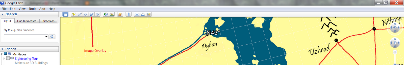
Click the insert Image Overlay button and select your image. Rename it something funky like “Imperial Eladria” or “The Known Firma” so you can identify it in the Tab to the left of Google Earth. These Tabs control anything you add over the top of Google Earth. I arrange them into areas of the world I am using, and then sort them by Layers (our Maps), Places (things we drop down to write descriptions) and Polygons (shapes we draw in Google Earth, which i use for political boundaries and could be used for environmental ones).

Here is the button on the top bar;


Drag the corners to resize the image, holding down shift to keep its aspect ratio the same. You can rotate the image with the diamond, but the rotate is a little funny, and if you rotate it you will apparently not be able to transfer the image over to the browser based Google Maps, as everything needs to be aligned straight up and down for it transfer to a Google Maps .kml file. This is another reason I am going to try and overlay all the layers in Photoshop first, so I can have the layers appear in Google Maps as well as Google Earth.


Decrease the transparency slider so you can resize the maps and shift them around to match up with any of your other maps you have already put onto Google Earth, or particular terrain features of the real world.
Make sure you check the box that says ‘Clamp to Ground’ to insure your maps don’t ‘Float’ over the ground. You can use the numbers to insure that the maps you want ‘above’ the others draw after the ‘lower’ maps.


Step 3
Add more maps.
You can now drop Places like you can do normally for Google Maps and Earth. You can include pithy descriptions about hexes and cities and the like. More importantly when you randomly come up with something on the fly, or generate something using a table, you can drop a place onto your world and record the location of it and what it is. I use polygons to designate countries, you can change the thickness and colours of the lines. You can also make them invisible, which could be useful for climates and environmental encounters as when you right click on an area inside a polygon it comes up with the polygons description.
Here are the controls and some examples;


You can then use the measuring functions during play (especially useful, to figure out the exact distance the PCs travel or how far away things are from each other.


Finally you want to "Save my Places As" - this will save your places and image overlays as a .kmz file with a name, rather than just you My Places for your Google Earth. You can then load this file onto other people's Google Earth and distribute your campaign map more simply than with paper copies (however your players could measure distance exactly and see your annotations, though if you turn these off when you save you should be able to generate a file without your placemarks etc).

Here are the controls and some examples;


You can then use the measuring functions during play (especially useful, to figure out the exact distance the PCs travel or how far away things are from each other.

You could even try and draw your entire world in terrain colour or hexmap it all out, and then drop places for cities and not include any labels on your drawings, but only in Google Earth (one of my goals).


So that's pretty much it. The potential that Google Earth has is really up to you. You could even add 3D graphics of buildings if you want.